Roads at the Ranch


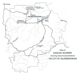
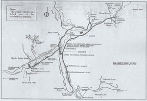
The "big picture" of the ranch's road system can be seen in the top map on the right, while the lower map zooms in on the areas where most people lived, worked and played. A few features merit a detailed exploration ...
The county road
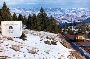
First, the county road was and still is the main public access to the ranch, in fact the only one most people are aware of. When coming from Antelope, we leave State Route 218 about 5 km east of Antelope and head south on Cold Camp Rd for about 4 km, turning left on Muddy Rd. After about 2 km on Muddy Rd, we enter the ranch, at the "Top of the Ranch". The road continues east for about 5 km, where it touches the corner of the Gautam the Buddha Grove area of the incorporated city of Rajneeshpuram, south for about 3 km, touching Desiderata, and east again for about 7 km -- passing Krishnamurti Lake at 1-2 km on that leg -- finally arriving in "downtown" Rajneeshpuram. At this point, the county road turns south to cross Farid Creek, which it has been following since Desiderata and goes up Kabir Creek, crossing it after about 2km and heading east toward Radha River outside the ranch, on its way to Mitchell.
The way-back county road
There is and was a little-known alternative to the county road in getting from Antelope to Mitchell via the ranch. If we proceed down Cold Camp Rd as before but keep going south rather than turning left onto Muddy Rd, that alternative begins. After about 4 km, that road becomes NE Divide Rd, skirting the ranch's western boundary and ending at NE Gosner Rd. Heading east on that road, we cross the upper reaches of Farid Creek after 2 km and after another 4 km come to the ghost town of Kilts, aka Donnybrook.
Kilts sits at the boundary of a remote area of the ranch property, where NE Gosner Rd crosses into the ranch for 8 km or so, crossing the many streams that are the upper reaches of Kabir Creek before exiting the ranch at another ghost town, Horseheaven, directly south from Patanjali Lake. From Horseheaven, it goes another 8 km, skirting the ranch's southeastern boundary before finally rejoining the county road on its way to Mitchell.
The fact that these roads have names does not in any way imply that they are paved. They are all high, winding gravel back-roads, rougher than the main county road. The "NE" in their names is also interesting. It seems to derive from an orientation to Madras, over 40 miles away to the southwest, perhaps because it is the Jefferson County county seat. These roads also appear on the whole ranch map, albeit without names, so they must have been in public use even then.
Mevlana Road
"Mevlana Bhagwan Road" -- "Mevlana" is a Sufi term of address meaning approximately "Beloved Master" -- is also shown on the top map, but it is not labelled anywhere. It was a continuation of Zarathustra Road, crossing the county road at Pythagoras and heading south along Kabir Creek. Bodhena writes, in Osho News:
- During his drives up the county road and onwards to the small town of Madras, Osho had been hassled several times by locals that were taking the opportunity to show their dislike with what was happening at the Ranch. He had also gotten a couple of speeding tickets, and once he ditched his Rolls and had to be taken back in the lead car.
- In months of hard work, we built our own road for him, on our own property. "Mevlana Bhagwan Road" was going up many miles past Lake Patanjali into a remote corner of our land, and he had it all to himself. Residents and long-term commune workers – oops! I mean "worshippers" – were invited periodically to go out and greet him where he would turn around at the end of the road before driving back.
- So, two or three times a month I'd pile into a van with another half-dozen people some time before drive-by. A short distance before our destination, we'd leave the road, continue a ways up a dirt track, leave our car, and hike up a slope for about half a mile before we'd get to the turnaround to line up and wait. Soon enough, he came cruising up the road. Yes, obviously he loved to drive. He handled the car with his usual grace, and looked pretty cool wearing his designer sunglasses. We got our namaste, and then he was gone again, and the hills around us were as silent as ever.
The downtown paved roads

Dirt roads create a lot of dust in the air for those nearby as cars and trucks drive by and kick it up. In fact, the dust in the air was identified as the probable cause (such as there was any cause) for the supposed epidemic of conjunctivitis (pinkeye) at the ranch. That scam came later than the paved roads but there was still plenty of dust to be found, and the paving did reduce the dust for those living, working and playing nearby.
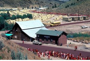
Those roads that did get paved -- far from all the ranch roads -- are shown on the second map above in dark thick black. And, a nice touch, instead of the usual black, they were a rich purplish-red. Roshani reports, in Osho News, that they were done before the Second Annual World Celebration in 1983.
A close look at the photo showing these paved roads suggests a non-alignment with the map which should be looked into. The roads are not exactly as portrayed in the map.
Do you have some info or stories to share about these roads? Contribute! <== (how to)
